
Walk a Tempe Street Directory
A reliable street-by-street search moves from land to people. Begin with one known address in the Maricopa County Assessor. Its card anchors the parcel number, or APN, the situs address, indexed owner, mailing address, subdivision, and linked deed. Situs means the physical location of the parcel. It is not the owner's mailing address. A match between those two addresses may support owner occupancy, but it does not prove who lives inside.
Next, open the Assessor Parcel Viewer and select parcels along the desired segment. Long streets may need smaller segments because results stop at 1,000 features. Exported parcel rows provide a repeatable working list. The street directory then branches into deeds, city records, and dated historical sources.
- Search the exact address in the Assessor and save its APN, owner, situs, mailing address, subdivision, and deed number.
- Select the street segment in Parcel Viewer with a line or polygon, then add or remove parcels and export the results.
- Open each current deed through the Recorder and confirm the legal description before linking a name to that parcel.
- Check Tempe permits, property cards, and code files for dated activity at the address. A project contact is not proof of residence.
- For a past household, consult a verified address-ordered directory and bridge old addresses with plats, parcel data, and maps.
This sequence prevents a common error: turning an owner list into a resident list. Arizona's personal voter portal is also not a browseable street roll. County voter-file access has a statutory-purpose form, charges, secure delivery, and restrictions on use and Internet posting.
If an online step fails, use the documented human channel. Assessor parcel history is available by email. Recorder staff and the Phoenix counter can help with book and page references, maps, or an unclear index cutoff. Community Development takes address-history requests online, at a kiosk, or by mail. The Tempe City Clerk's JustFOIA route can direct a request that falls outside those systems. Counter inspection of city records is free, though copying, certification, and redaction can affect delivery.
Search Tempe Property Addresses
The Assessor's single search box accepts three practical keys. Address searches use a standardized form: number, optional direction, street name, abbreviated street type, and optional city, state, and ZIP. The official search help advises using a full owner name and not shortening the first name. If the public card lacks enough history, the office directs users to request a parcel history report at asr.pa@maricopa.gov.
| Search key | Format | Street-directory use |
|---|---|---|
| Street address | Number, direction, name, short type | Find the parcel at one physical site |
| Owner | Full owner name | Find other parcels indexed to the same owner |
| APN | Any separator format | Keep the parcel stable when an address changes |
A parcel card can show owner and mailing address, situs address, APN, legal description, MCR or subdivision reference, deed link, five years of values, residential traits, sketch, sales, and tax links. The APN and legal description are the strongest bridge when street text varies.
Map Tempe Streets by Parcel
Parcel Viewer can search by owner or APN, subdivision name or MCR, section-township-range, ZIP, and Map ID. Mouse tools include points, lines, polylines, freehand lines, and polygons. Results can be added to or removed from the active set and exported as an attribute table, CSV, GeoJSON, or feature collection. Those options turn a map into a transparent street-by-street inventory.
Use a narrow shape along one side of a road when a buffer sweeps in too many rear parcels. Save the search URL and note the date. Parcel data can change after sales, splits, or new subdivisions. Physical and mailing addresses remain separate fields in the official feature service, which makes the distinction visible rather than inferred.
- Parcel
- A mapped unit of land with its own APN and legal description.
- Situs address
- The physical property address, distinct from the owner's mail address.
- Plat
- A recorded map that identifies subdivision lots, blocks, streets, and easements.
- Criss-cross directory
- A dated directory arranged by street and house number rather than only by surname.
Tempe Permits Follow Addresses
The Tempe Accela Citizen Portal allows anonymous searches across building records. Street number, direction, name, type, unit, parcel, lot, city, state, and ZIP can all narrow a search. A known project or record number can go straight to one file. Date pairs, record type, business name, professional name, and license type add other routes.
The successful manifest capture below shows the official permit-search surface used for the Tempe street directory.
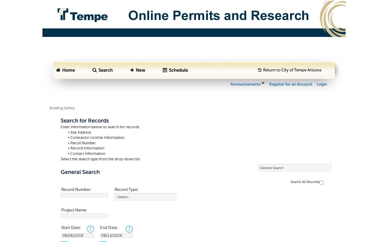
The form's separate address and parcel fields help distinguish work tied to a site from a name tied only to a project role. Planning entries before April 2015 may be incomplete, so silence in the portal is not a full negative.
Request Tempe Address Histories
When Accela comes up short, Tempe Community Development accepts online, kiosk, and mail requests for building permits, certificates of occupancy, property records, code violations, inspection histories, planning files, and property cards or address histories. The counter is at 31 E. Fifth Street, Garden Level East. The city states an average processing time of twenty business days.
A missing old plan needs context. Tempe did not retain single-family residential plans until electronic submission began in 2020. Before then, those plans were discarded one year after final inspection. Pair a gap with the permit record, Assessor construction data, historic aerials, or a Sanborn map. The live code map is even more time-sensitive because closed cases remain for only two weeks.
Note: Save a code case number and access date promptly; the live layer is not a permanent street history.
Chain Tempe Deeds by Street
The Maricopa County Recorder reports more than 52 million documents. Its index covers deeds, deeds of trust, releases, liens, judgments, plats, covenants, affidavits, and other instruments. Search and unofficial images are free. Official copies cost $1 per page, and certification adds $3 per document.
Start with the deed number from the parcel card. Record the grantor, who transferred the interest, and the grantee, who received it. Then search that seller as an earlier grantee and verify the same legal description, subdivision, lot, and block. The modern Research mode can search an address or legal description with phrases, OR, and thesaurus matching, but it covers only the latest two years. That quirk makes it useful for recent work and unsafe as a stand-in for the older index.
Two-year limit. Older Tempe street history requires names, document numbers, book and page references, plats, and legal descriptions rather than address full text.
Tempe Street Records Compared
No single public record identifies every person at an address. The Tempe street directory works by comparing records that answer different questions and were created at different times.
| Record Set | Keeper | What It Shows | Access |
|---|---|---|---|
| Property roll | Maricopa Assessor | Owner, situs, mailing address, APN, deed | Free portal; history by email |
| Parcel geography | Assessor GIS | Street parcels, ZIP, subdivision, export | Free viewer; 1,000-result cap |
| Deeds and instruments | County Recorder | Parties, date, type, legal description | Free index/image; paid official copies |
| Permits and inspections | Tempe Community Development | Projects, dates, roles, address history | Portal, counter, online/kiosk/mail request |
| Code cases | City of Tempe | Status, violation, inspector, case number | Live map; short closed-case window |
| Historical directory | Museum and State Library | Dated names or businesses at addresses | Digitized and appointment research |
The parcel number binds the first four record groups even when a road label changes. A directory entry is evidence for its publication year only. A permit contact may be an owner, architect, firm, or contractor. Each name needs its role stated.
Voter information requires special care. The personal Arizona Voter Information Portal uses identity details to confirm a person's own status and election information. It does not support an open walk down a Tempe street. Maricopa County maintains the public voter file under A.R.S. § 16-168, but requesters must state an authorized purpose. Delivery uses a secure link and separate password email, and the link expires after two weeks. Protected addresses and sensitive identifiers remain withheld.
Tempe Roads Change Names
Tempe's address grid divides north from south at Rio Salado Parkway and east from west at Mill Avenue. Numbered streets begin at Rio Salado and proceed south. Tempe spells numbered street names, while Phoenix uses numerals. At city lines, several major roads take new names: Mill becomes Van Buren in Phoenix, Curry becomes Washington, Rural becomes Scottsdale Road, Apache becomes Main Street in Mesa, McClintock becomes Hayden Drive, and Priest becomes 56th Street in Chandler.
Search both road names when a trail crosses a boundary. Historic addresses can shift without a move as well. City property research records 221 E Sixth as formerly 6 W Fifth and 2029 E Apache as formerly 710 S Ash. Those examples do not prove one universal renumbering year. Use the APN, plat, legal description, historic property name, and Sanborn footprint as the bridge.
Note: Tempe's 1890 Sanborn map coverage predates the town's 1894 incorporation, so mapped property evidence can begin before municipal minutes.
Tempe Street Directories Over Time
Historical address-to-name work depends on the volume. The 1968 Polk's Mesa-Tempe directory explicitly includes a complete street and avenue guide with household and business-space occupants, phones, and ZIP codes. It is the strongest verified local criss-cross lead. By contrast, the 1925 Phoenix and Salt River Valley volume has Tempe rural-route pages, while its householder street guide is Phoenix-only.
That distinction matters. A street section cannot be assumed just because a book includes Tempe names. The full historical shelf, publishers, and reading methods belong in the Tempe city directory collections. For a street search, record the volume year, section heading, printed address, and spelling exactly. Then compare it with the parcel, census, and map evidence rather than treating old print as current fact.
Tempe Public Library provides Ancestry Library Edition and HeritageQuest only on library computers. Tempe History Museum offers appointment research and a public catalog of more than 70,000 objects. The Arizona State Research Library keeps print and microform directories, maps, newspapers, and vertical files. Together, these channels cover digitized scans, database access, and staff-assisted shelf research without claiming that every year is online.
Limits of Tempe Street Lookup
Property records do not name all occupants. Renters, children, extended family, roommates, and unlisted people may leave no open address-keyed record. Mailing addresses can belong to owners who live elsewhere. DMV information is restricted by federal law, and utility customer data is not an open street roster. Arizona's Address Confidentiality Program supplies a substitute address to eligible survivors, while protected voter records may be sealed.
The best street directory conclusion is narrow and dated: a county record indexed an owner, a deed named transfer parties, a permit tied roles to a project, or a historical volume printed a household at an address in one year. Missing results do not prove that nobody lived there.
Lawful use. Tempe address records are for lawful personal research. Public access never permits stalking, harassment, intimidation, or harm.