
Tempe ZIP Coverage Table
Tempe has five major geographic delivery areas, plus an institutional campus code and two post-office-box codes. That distinction is central to a useful ZIP code directory. A geographic code can help filter parcel or permit records. A special code may describe how mail is routed without creating a neighborhood polygon. The official city report maps the five geographic areas, while USPS controls delivery assignments for a specific address.
| ZIP Code | Areas Covered | Post Office | Notes |
|---|---|---|---|
| 85281 | Downtown, Mill Avenue, north-central Tempe and much of the ASU street vicinity | Verify the exact address with USPS | Standard area; northeast portion changed in 2022 |
| 85288 | East and northeast Tempe along the Apache corridor | Tempe Apache Post Office | Effective July 1, 2022 |
| 85282 | Central Tempe, Southern, Broadway, Library and Museum area | Exact facility not established | Standard geographic area |
| 85283 | South-central Tempe, Baseline, Guadalupe, Kiwanis and The Lakes | Exact facility not established | Standard geographic area |
| 85284 | Far south, Warner, Corona and ASU Research Park area | Exact facility not established | Standard geographic area |
| 85287 | ASU Tempe institutional mail | ASU Mail Services | Not a general residential polygon |
| 85280 | Tempe post-office boxes | Facility not established | PO-box-only code |
| 85285 | Tempe post-office boxes | Facility not established | PO-box-only code |
Do not turn 85287, 85280, or 85285 into ordinary residential areas. The ASU code routes PO Box 87XXXX and campus mail. The two box-only codes likewise need a known box or custodian record rather than a drawn neighborhood. Where the exact postal facility was not verified, the Tempe ZIP code directory leaves it unstated instead of guessing.
Tempe’s Five Geographic ZIPs
The City of Tempe’s five-ZIP map treats 85281, 85282, 85283, 85284, and 85288 as the major residential and geographic set. They also reflect distinct parts of the city’s growth. Downtown and ASU streets sit in the older north grid, central areas spread around Broadway and Southern, and far-south Tempe reaches Warner, Corona, and the research park.
Neighborhood names can add context after the code is known. Maple-Ash and downtown fit a different development pattern from The Lakes, Kiwanis Park, Warner Ranch, or Corona Ranch. Yet a named area is not a substitute for exact postal verification. Boundaries can cut across familiar local labels, and parcel records remain more precise than a broad neighborhood name.
Tempe’s growth helps explain the layers. The city expanded from 2.6 square miles in 1950 to 17.5 in 1960, 25.3 in 1970, and 36 in 1980. Annexation history can decide which municipal custodian holds an older record even when modern mail says Tempe.
The 85288 Tempe Split
USPS created 85288 for east and northeast Tempe effective July 1, 2022. The change shifted 12,704 deliveries from 85281 while the Apache Post Office continued handling the area. That makes the split a records issue, not just a postal fact. A current parcel may show 85288 while an older directory, permit, deed, or saved database record still shows 85281 for the same place.
The USPS announcement for the new Tempe code preserves the effective date and delivery count.
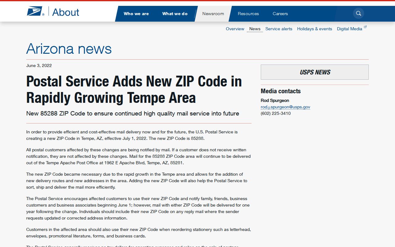
The captured notice is the best date anchor for comparing old and new files. Search both 85281 and 85288 when the target address lies in the Apache corridor and the record crosses 2022.
Search Tempe Records by ZIP
A ZIP code directory narrows geography, but the next source must match the question. The Maricopa Parcel Viewer can select a ZIP and expose parcel polygons, indexed owners, physical and mailing addresses, APNs, subdivision fields, and deed links. It does not list every person nearby. Tempe Accela can search building records with parcel, street, unit, city, state, and ZIP inputs. Permit contacts show a role in a project, not residence.
- Verify the current postal assignment for the exact address. For northeast records, note whether the source predates the 2022 split.
- Open the Maricopa County Parcel Viewer and use Search By with the geographic ZIP. Keep the 1,000-result cap in mind.
- Inspect parcel results for physical address, APN, indexed owner, mailing address, subdivision and deed link. Do not treat the owner list as a resident roll.
- Use Tempe Accela for address-linked building records, or ask Community Development for a property card or address history.
- For voter data, use the personal portal for an identified record or follow Maricopa County’s purpose, fee, privacy, and delivery rules for a file request.
Once the results narrow to an address or segment, the Tempe street directory carries the search to parcel and deed detail. ZIP-wide evidence should stay at the geographic level until an exact parcel is confirmed.
Tempe ZIP Search Fields
The two strongest local portals use ZIP differently. Parcel Viewer treats it as a spatial filter, while Accela uses it within a structured address form. Both have other fields that reduce false matches. A broad code alone may return too much, so pair it with a street, parcel, unit, subdivision, or map shape.
| Portal | ZIP-Capable Input | Helpful Companion Fields | Result Limit or Caveat |
|---|---|---|---|
| Assessor Parcel Viewer | Search By ZIP | APN, owner, subdivision, MCR, map shape, buffer | 1,000 results; indexed owner is not occupant |
| Tempe Accela Building | ZIP in address group | Street number, direction, name, type, unit, parcel and lot | Planning entries before April 2015 may be incomplete |
| Arizona voter portal | County and identifying inputs | Name, birth or registration information as requested | Personal verification, not open ZIP browsing |
| County voter-file request | Requested geographic extract where authorized | Statutory purpose, format and delivery details | Fees and use limits; no Internet posting |
If an online parcel view is too broad, the Assessor offers a parcel-history fallback by email at asr.pa@maricopa.gov. Tempe Community Development accepts online, kiosk, and mail requests and states an average twenty-business-day processing time. Those channels matter when the current portal omits an older address record.
Special Tempe Mail Codes
Special codes prevent a ZIP code directory from behaving like a simple neighborhood list. ASU’s 85287 is an institutional mail route for PO Box 87XXXX and 85287-XXXX formats. It can confirm a campus mailing context, but it should not be mapped as a conventional residential district. Campus affiliations and a large, changing university population make that distinction especially important in Tempe.
Codes 85280 and 85285 serve Tempe post-office boxes. A box code describes where mail is collected or routed, not the street location of the box holder. The official research did not establish exact facilities for those codes, so use USPS verification for a specific mailing need rather than assigning them to a guessed part of town.
- ZIP
- A five-digit USPS delivery code. It organizes mail and does not define a city boundary.
- ZIP+4
- The five-digit code plus four digits that narrow delivery to a smaller segment, box group, or destination.
- PO-box ZIP
- A code used for post-office boxes rather than an ordinary street-delivery polygon.
- Unique ZIP
- A code assigned to a high-volume institution or other single destination, such as campus mail.
- Carrier route
- A USPS delivery route within a code. It is smaller than the full ZIP area but is not a parcel or city line.
Tempe’s Address Grid
Postal filtering works better when the street grid is understood. Rio Salado Parkway along Town Lake divides north from south, while Mill Avenue divides east from west. On a north-south street, east-side addresses are odd and west-side addresses are even when facing north. On an east-west street, south-side addresses are odd and north-side addresses are even when facing east.
Tempe spells numbered streets, such as First Street, while Phoenix uses numeral forms such as 1st Street. Numbered streets begin at Rio Salado and proceed south. Engineering assigns addresses and private-street names; Development Services assigns suites. Use the official format when an Assessor or permit search fails, since a direction, spelled number, unit, or street type can change the match.
Historic property files also prove that one place can have more than one address over time. Bridge an old address to the present with the APN, legal description, subdivision plat, property name, and Sanborn footprint. No official source established one universal Tempe renumbering date.
Tempe Border Road Quirks
Six major roads change names across Tempe’s borders. Mill Avenue becomes Van Buren in Phoenix. Curry becomes Washington there. Rural becomes Scottsdale Road, Apache becomes Main Street in Mesa, McClintock becomes Hayden Drive, and Priest becomes 56th Street in Chandler. A person or parcel can stay on the same road corridor while an older record uses the other city’s name.
Search both road names when the record sits near a border or crosses an annexation era. Chandler’s 1974 Ray Road annexation landlocked Tempe, adding another reason not to equate a postal label with municipal jurisdiction. The city that delivers services, the city name preferred by USPS, and the county parcel location answer different questions.
Note: Road-name continuity and ZIP continuity are separate checks, so preserve both the parcel number and the record date during a border search.
ZIP Lines and Tempe Limits
A USPS city name is a delivery convention. It does not prove that an address lies within Tempe’s incorporated boundary, receives Tempe services, or belongs in a Tempe municipal record set. The parcel polygon and city boundary layer answer geography more precisely. The responsible office follows jurisdiction and record type, not the way a mailing label looks.
This mismatch matters in both current and historic research. Tempe expanded rapidly through annexation, while the postal system later split the northeast delivery area. A permit request may belong with Tempe Community Development, a deed with the Maricopa County Recorder, and voter access with the county or state. Verify each layer independently.
Boundary check. Use a ZIP to narrow the search, then confirm the parcel and incorporated city before drawing conclusions about a Tempe address or resident.